
Research & Applications
Development
The Land Use Change Impact Assessment tool LUCIA has been developed by Dr. Carsten Marohn and Prof. Dr. G. Cadisch at the Institute for Plant Production in the Tropics and Subtropics, University of Hohenheim, since 2008. The model was developed for the Special Research Program SFB 564 (The Uplands Program) funded by the German Research Foundation and is maintained and further developed in subproject C4.2 (until June 2012) and transfer project T6 (until June 2014).
During the following Ellrichshausen Foundation project, LUCIA has been extended, hard-coupled to the livestock generator LivSim and soft-coupled to the multi-agent system MPMAS.
From 2020-2025 LUCIA has been further developed, particularly with respect to dry land areas and tree based intercropping systems in the EU funded project SustainSahel (Synergistic use and protection of natural resources for rural livelihoods through systematic integration of crops, shrubs and livestock in the Sahel).
The intercropping module has been validated under the EU project Leg4Dev.
Currently LUCIA is developed within the EU-funded GALILEO project along a gradient of semi arid to subhumid sites in Africa.
Scope
LUCIA aims at assessing impacts of land use change in small mountainous catchments on soil productivity and fertility, biomass production, watershed functions and environmental services. Emphasis is on matter flows in the landscape that connect upland and lowland areas, and with the recent expansion also includes resource use trade-off analysis as a result of livestock-crop-tree-soil interactions.
Applications
The model can be used to assess effects of land use change and management on
- Soil water balance,
- Run-off, erosion / deposition,
- Nutrient budgets and crop production,
- CO2 sequestration / release in / from plants and soil,
- Litter inputs and organic matter turnover
- Animal manure and grazing effects
- Crop/tree residues as feed on livestock performance
- Competition for resources in intercropping systems
As a spatially explicit landscape model, LUCIA includes routing of matter flows along topography-determined drainage directions.
As a research tool, LUCIA has been used in the Uplands Programm and applied in watersheds of Mae Sa, Chiang Mai province in North Thailand and Chieng Khoi, Son La province in Vietnam.
For teaching, LUCIA has been applied at the University of Hohenheim, Chiang Mai University, Kyushu University. A course at Hanoi Agricultural University was held in Nov 2011.
Scenarios on improved natural resource management, intercropping and rotations were run with stakeholders in Western Kenya (see connessa.uni-hohenheim.de).
Grazing and livestock impacts were investigated in the Borana region of East Africa and in the sahel region of Westafrica (Mali, Burkina Faso, Senegal).
Temporal resolution
Daily, with hourly sub-timestep for infiltration, runoff and erosion
Spatial resolution
User-defined pixel size
Software
LUCIA is written in PCRaster, a combination of dynamic modelling language and GIS developed at the University of Utrecht.
Raster maps in ASCII format
- Topography (DEM)
- Soil classes
- Land cover classes
- Sampling points for output reports (time series)
- Further maps are derived from these
Weather data in daily resolution
- Rain fall (mm)
- Air temperature (oC)
- Soil (5cm depth) temperature (optional, automatic estimation available)
- ET0 (mm, reference evapotranspiration on a standardised grass pitch)
- Solar radiation (W m2)
Soil data
All data are required for each soil class specified in the soil map (s. above). For the two soil horizons represented in LUCIA
- SOC
- Total N
- Available P
- Texture
- Bulk density
- Horizon thickness are the main user inputs;
- Soil physical parameters like Ksat are calculated from these.
Plant data
For each land cover type, the required input data at stand level are grouped into categories:
- General plant data, such as temperature sums required until flowering and maturity, water use efficiency, maximum leaf area index
- Development-dependent allocation ratios: The shares of carbohydrates from photosynthesis, which go to roots, stems, leaves and fruit during different development stages of the plant. These data are derived from two user-defined cardinal points.
- NPK concentrations for each plant part - i.e. root, stem, leaf, fruit - during all stages of physiological development, estimated from two cardinal points
- there are some more; a complete list can be found in the manual.
We provide default datasets for a range of tropical annual and tree crops. The plant parameters in LUCIA are basically the ones required for the WOFOST model, and data are available in several research papers as well as in the WOFOST database.
Biomass, LAI and other parameters for existing perennial vegetation (e.g. old growth forest, natural succession or plantations present at the beginning of the simulation) are estimated from measurements or empirical equations:
- Direct input (in case of existing destructive measurements)
- allometric equations (for uniform even-aged stands like plantations)
- a plateau function based on stand age
- a Gompertz function that includes a coefficient for plant death
These functions can be selected alternatively for each land cover type.
Management
- Planting dates (up to three per year),
- Rates and NPK concentrations of fertiliser and manure and their application dates (optional)
- Tillage (optional) and
- Burning (dates and ratio of firewood collection, date and efficacy of burning) (optional)
- Pruning dates and severity (optional)
Soil water, run-off and erosion related outputs for Mae Sa Noi, Chiang Mai, Thailand
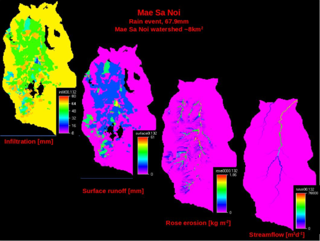
Pixel-based infiltration, run-off, routed soil erosion and streamflow in the Mae Sa Noi watershed after a rain event of 67 mm.
Land use and erosion in Ban Tat watershed, Moc Chau province, Vietnam
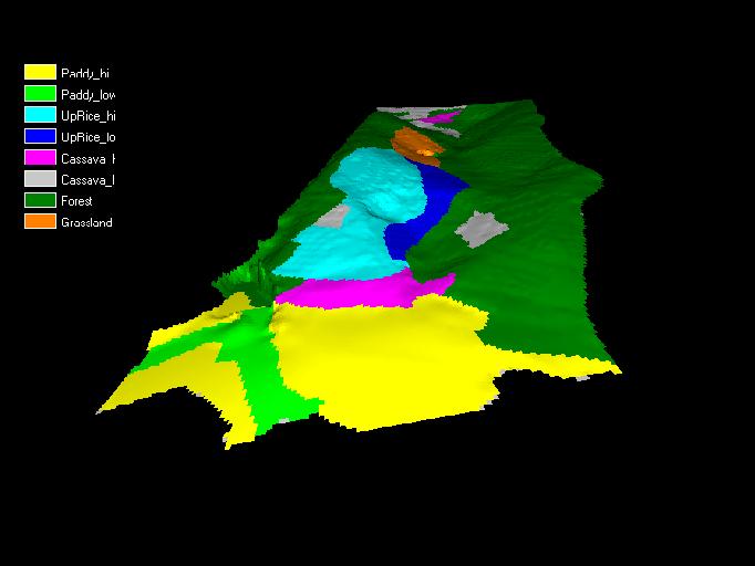
Land use distribution within the watershed
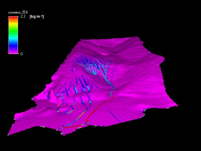
Erosion after a rain event as influenced by canopy cover of different vegetation types in Ban Tat watershed, North Vietnam. Watershed area 3.5 ha.